Home »
Blog »
Hyderabad Metro Phase 2 New Statitions List
30 Jun 2026
The Hyderabad Metro Phase 2 project is one of the biggest public transport expansion projects in Telangana. It aims to improve connectivity across Hyderabad by extending metro services to new residential, commercial, IT, industrial, and airport corridors.
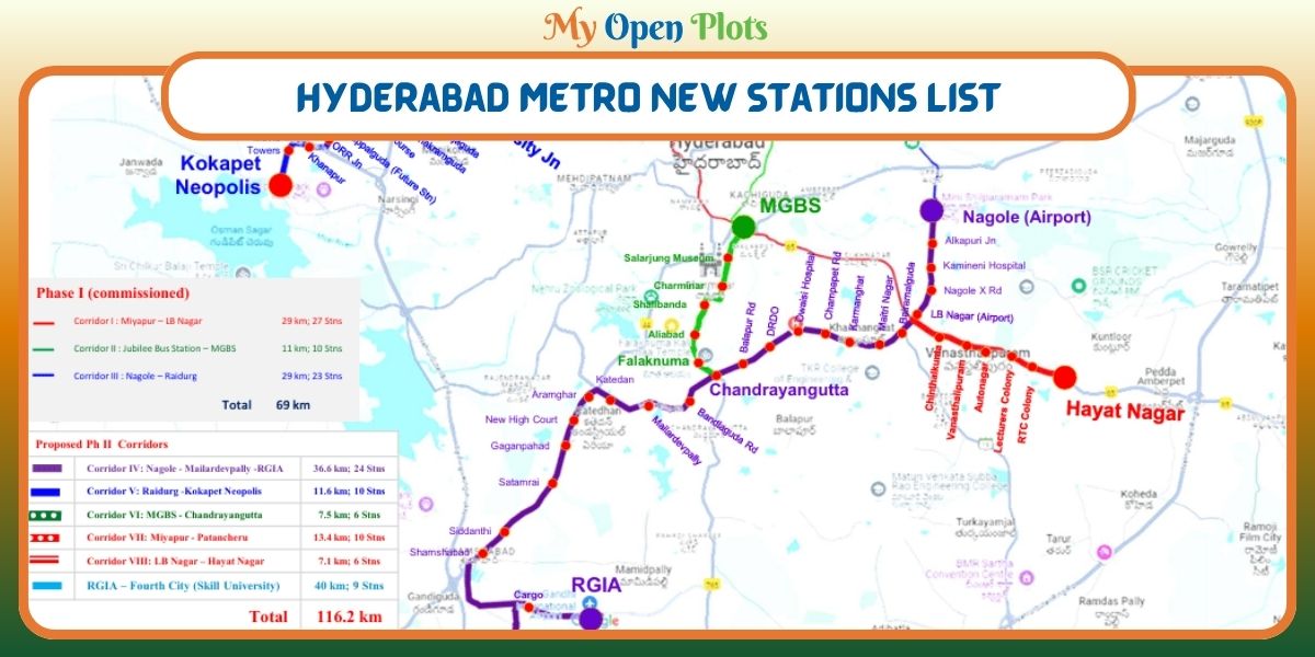
The Telangana Government has proposed five new metro corridors covering approximately 76.4 km with 54 proposed stations. These corridors will connect major growth areas, reduce travel time, improve public transport accessibility, and support Hyderabad's future urban development.
If implemented as planned, Hyderabad Metro Phase 2 will strengthen connectivity to the Rajiv Gandhi International Airport (RGIA), Financial District, Kokapet, Patancheru, Hayathnagar, Old City, and several rapidly developing residential areas.
Hyderabad Metro Phase 2 is the proposed expansion of the existing Hyderabad Metro Rail network. The project is being developed by Hyderabad Airport Metro Limited (HAML) and Hyderabad Metro Rail Limited (HMRL).
The proposed expansion includes five new metro corridors:
Corridor 4: Nagole to Rajiv Gandhi International Airport (RGIA)
Corridor 5: Raidurg to Kokapet Neopolis
Corridor 6: MGBS to Chandrayangutta
Corridor 7: Miyapur to Patancheru
Corridor 8: LB Nagar to Hayathnagar
The project is designed to improve connectivity to emerging residential hubs, IT parks, industrial corridors, educational institutions, and commercial centers. It also supports Hyderabad's long term urban mobility plans by reducing road congestion and promoting sustainable public transport.
Hyderabad Metro Phase 2 Proposed Stations List
Corridor IV: Nagole To Rajiv Gandhi International Airport (RGIA)
Length: 36.6 km
Proposed Stations From Nagole
Nagole X Road
Alkapuri Junction
Kamineni Hospitals
LB Nagar
Red Line Interchange
Bairamalguda
Maitri Nagar
Karmanghat
Champapet Road
Owaisi Hospitals
DRDO Kanchanbagh
Balapur Road
Chandrayangutta
Green Line Interchange
Bandlaguda Road
Mailardevpally
Katedhan
Aramghar
New High Court
Gaganpahad
Satamrai
Siddanthi
Shamshabad
RGIA Cargo
This is the longest corridor in Hyderabad Metro Phase 2. It will provide direct metro connectivity between eastern Hyderabad and the airport. The corridor is expected to benefit commuters travelling from Nagole, LB Nagar, Chandrayangutta, Aramghar, and Shamshabad.
Corridor V: Raidurg To Kokapet Neopolis
Length: 11.6 km
Proposed Stations From Raidurg
Biodiversity Junction
Khajaguda
Nanakramguda
Golf Course
Wipro Circle
Puppalaguda
ORR Junction
Khanapur
Movie Towers
Kokapet Neopolis
This corridor connects Hyderabad's major IT hub with the rapidly developing Kokapet and Neopolis region. It is expected to improve connectivity for professionals working in the Financial District and support future commercial and residential developments.
Corridor VI: MGBS To Chandrayangutta
Length: 7.5 km
Proposed Stations From MGBS
Salar Jung Museum
Charminar
Shalibanda
Aliabad
Falaknuma
Chandrayangutta
This corridor is significant because it extends metro connectivity into Hyderabad's historic Old City. It will improve accessibility to important heritage landmarks, educational institutions, business areas, and densely populated neighborhoods.
Corridor VII: Miyapur To Patancheru
Length: 13.4 km
Proposed Stations From Miyapur
Miyapur X Roads
Allwyn X Roads
Madinaguda
Chandanagar
BHEL
Jyothinagar
Beeramguda
RC Puram
ICRISAT
Patancheru
This corridor extends metro connectivity towards Hyderabad's western industrial and residential belt. It is expected to benefit daily commuters travelling between Miyapur, BHEL, RC Puram, and Patancheru while supporting industrial and residential growth.
Corridor VIII: LB Nagar To Hayathnagar
Length: 7.1 km
Proposed Stations From LB Nagar
Chintalakunta
Vanasthalipuram
Auto Nagar
Lecturers' Colony
RTC Colony
Hayathnagar Khalsa
This corridor will improve metro access for residents living in eastern Hyderabad. It is expected to reduce traffic congestion on the Hyderabad–Vijayawada Highway and provide better public transport connectivity to Hayathnagar and nearby localities.
The Hyderabad Metro Phase 2 project is expected to transform public transportation across the city by expanding metro connectivity to new residential, commercial, industrial, and airport corridors.
Note: The stations listed above are based on the currently proposed Hyderabad Metro Phase 2 alignments. Station names and alignments may change as the project progresses through detailed design, approvals, and construction.